

On Problematic Border Settlements
On Problematic Border Settlements
A Brief Look at the Treaty of Lausanne, the Durand Line, and the Sykes-Picot Agreement

In my last post I briefly mentioned the Treaty of Lausanne and the increasingly vocal opposition of the Turkish government to some of its longstanding terms. A closer look at these grievances, which to Turkish statesmen highlight the increasing incompatibility between the terms of the treaty and contemporary political realities on the ground, led me to ponder on other relevant examples of inter-state demarcation where the drawing of borders has drastically shaped the fate of peoples who live under them, and where potential for conflict remains high even today. Since state-level grievances with established borders and treaties can, and often do, cause tensions, and can at times even lead to conflict, its important to understand what makes some territorial delineations particularly troublesome then and now.
I will discuss three problematic inter-state borders from the Middle East and Central Asia regions that pose a clear risk to lasting stability: The Treaty of Lausanne, The Durand Line, and the Sykes-Picot Agreement. While there are countless more examples elsewhere in the world, I believe these will serve particularly well to highlight instances where the drawing of borders has failed to account for local realities, and directly contributed to contemporary conflict.
1. The Treaty of Lausanne (And What Preceded It)
To understand this treaty, we must begin by looking at an earlier arrangement by the Triple Entente as they moved to abolish the Ottoman Empire following World War I. The post-war division of the former Ottoman Empire was first decided in the 1920 Treaty of Sèvres, which sought to divvy up the Anatolian Peninsula among the Allied powers and establish an autonomous Kurdish (as well as an independent Armenian) state within the borders of modern-day Turkey. However, parts of the proposals were deeply problematic, such as the proposed Kurdish autonomous territory, which would not encompass the entirety of the Kurdish people living in the region. Because of this the agreement did not necessarily satisfy Kurdish demands for self-determination, especially as the proposed territory in the Treaty of Sèvres (see below) did not include the significant Kurdish communities living in Iraq, Syria, or Iran. Nor did the treaty come anywhere close to satisfying the Turks, as what remained of Ottoman lands were being carved up by the victorious powers, and acceptance would leave the Turks with nothing but a rump state.

Treaty of Sèvres, (August 10, 1920). The treaty abolished the Ottoman Empire and obliged Turkey to renounce all rights over Arab Asia and North Africa. It included provisions for an independent Armenia, for an autonomous Kurdistan, and for a Greek presence on the Anatolian west coast, as well as Greek control over the Aegean islands.
Unsurprisingly, given that one side had much to gain while the other was being dispossessed, Sèvres was roundly accepted by all actors except the Turks. A considerable Turkish resistance formed, over time transforming into the Turkish National Movement under the leadership of Musfata Kemal Atatürk. The consolidation of the political movement led to clashes as the Turkish Nationalists sought to roll back Allied claims as expressed in the treaty. The years following Sèvres saw the Turkish Nationalist Movement defeat both the Russian-backed Armenian forces, as well as largely British-backed Greek armies, effectively halting the carving of former Ottoman lands in the Anatolian Peninsula. As the Allies lacked the political will to undo the gains made by the Turkish Nationalist Movement, the European powers compromised and sought to draw up a new treaty in 1923 - The Treaty of Lausanne. This treaty would cement Turkish sovereignty over what we consider the borders of modern Turkey today and stabilized the restless situation in Anatolia by acknowledging Turkish claims. For doing that, at least, it was considered a far superior territorial settlement than the Treaty of Sèvres that came before it. With the signing of the Treaty of Lausanne, many conflicting claims in the region were resolved, and the dispossession of former Ottoman lands in the heart of Anatolia came to an end.

Treaty of Lausanne (July 24, 1923) and the New Turkey as it stood in 1926. The treaty set the boundaries between Turkey, Greece, and Bulgaria. Turkey was forced to give up its claims on Cyprus, Iraq, and Syria. Turkey was also recognized as the legal successor state to the Ottoman Empire, with its capital at Ankara.
But where it failed was indecision and inaction regarding the Kurdish question. By neglecting the local Kurdish populations and leaving unchanged the borders of the Sykes-Picot agreement (which I will discuss below) in Iraq and Syria, the powers that drafted the treaty left open the door for a century of violence between the forces of nationalism, Turkish and Kurdish. Even beyond Turkey, the horrific conflict in Syria and Iraq today, as well as other tensions that stem from the unaddressed ethnic realities, demonstrate the treaty's residual failings as the Kurdish population remains scattered as a minority across multiple states. Perhaps a hundred years of bloodshed could have been avoided if the relevant statesmen involved in the drafting of the Treaty of Lausanne had sought to address the issue of Kurdish statehood then and there. The lack of international political will for addressing the question of an independent Kurdish state, has no doubt caused death and destruction, but for many, the alternatives seem far worse. And so here we are, almost a hundred years after the signing of the treaty with the Kurdish state still in limbo. With an increasingly nationalistic Turkey on the rise as a powerful regional player, and with the withdrawal of U.S. support for Kurds in the Syrian conflict, it doesn't seem likely that a solution favourable to the Kurds will be found anytime soon.
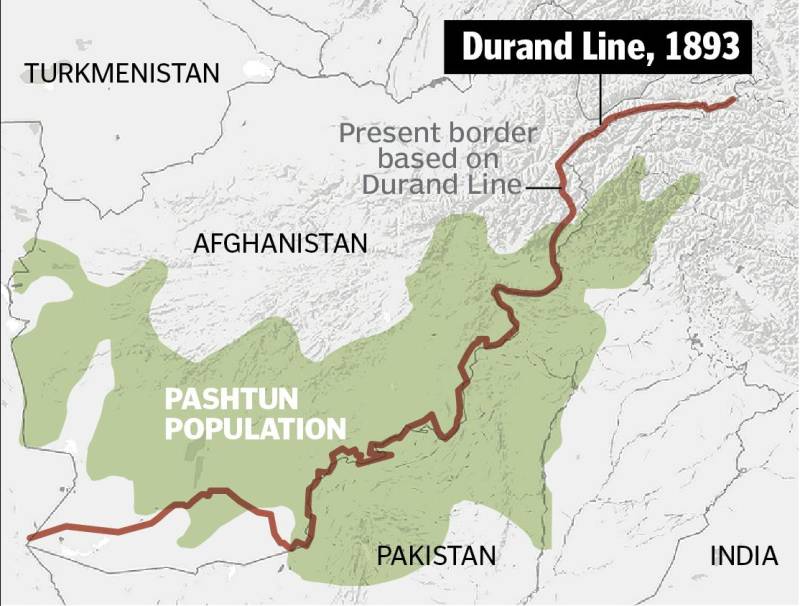
2. The Durand Line
The border established in the Hindu Kush in 1893, running through tribal lands held primarily by Pashtun and Baluch tribes, separated Afghanistan from British India and marked the limits of British influence in Central Asia at the tail-end of the 19th century. The boundary is named after a civil servant posted in British India, Sir Henry Mortimer Durand, who negotiated the border with the Afghan Emir at the time, Abdur Rahman Khan. The context surrounding this delineation should be largely approached within the broader conflict between The British and Russian Empires in Central Asia, often referred to as "The Great Game." The British at the time were determined to attain geographic security for its Indian territory, as conflicts with local Afghan tribes were a serious source of insecurity and a thorn in the side of British policymakers. Politics of the time were emblematic of a perception that any potential Russian gains in the region were perceived to signify a direct threat to British influence. These tensions between Russian and Afghan, Afghan and British, and Russian and British interests occasionally spilled over to produce large scale war, as was the case with the First Anglo-Afghan War (1839-1842) and the Second Anglo-Afghan War (1878-1880). The results of British efforts to settle this tumultuous frontier would eventually lead to the establishment of the Durand Line, forming a recognized border separating Afghan and British areas of interest.
The rationality behind the Durand Line was primarily a geographic one. As the border runs up the Hindu Kush mountain chain it marks a geographic barrier which, in the eyes of the British authorities, had the potential to serve as a defensible border. In particular, Britain was seeking control of the Khyber Pass. An important trade route between Central Asia and the Indian subcontinent and, more critically to the British, a vital strategic military choke point which made any potential Russian military manoeuvring difficult. Further north from this border, on the other hand, was an area that the Russians could tangibly threaten, so the importance of the mountain chain as well as its choke points to British military positions cannot be understated. The geo-strategic nature of the Duran Line means it served to provide a defensible forward position for British India amidst both the more local conflict with Afghan tribes, as well as the broader geopolitical clash between the British and the Russians.
And that's where its sensibilities seem to end. The problem is that while the strategic benefits of the mountain range and the Khyber Pass may have made a lot of sense to the British when formulating the Durand Line, it completely ignored realities on the ground as pertains to the people that make up the area, that is, that the demarcation cuts through a region long inhabited by Pashtun tribes. Its western limits bordering Iran, its eastern bordering China, ethnic Pashtuns had a border drawn between them, and to this day considerable Pashtun communities live on either side of the border, - modern day Afghanistan and Pakistan. This has led to a clear dissonance between de jure and de facto realities. The border is internationally recognized as the western border of Pakistan, while Afghanistan has refused to recognized the border altogether. This is partly due to the fact that Pashtuns form a considerable majority of the population in Afghanistan (42%), whereas they are a minority in Pakistan (15.4%), thus political support and recognition of the Durand Line is weak where Pashtuns have more influence in politics.

The Durand Line, (November 12, 1893) The single-page agreement contains seven short articles, including a commitment not to exercise interference beyond the Durand Line, effectively establishing respective spheres of influence between Afghanistan and the British Empire. Source: The Nation, available here.
The consequences stemming from the establishment of the Durand Line are wide-spread and far beyond what my light research here can reveal. Today, the border remains largely untouched in legal terms, while also no closer to stability than perhaps it had been in the 19th century. Perhaps the instability that plagues this region could have been mitigated had the Durand Line agreement sought to incorporate the Pashtun people within a single state, or at least not divided them as it did. The sad truth is that the Pashtuns have never been in a position to formulate a state of their own independently, nor have they received the international support necessary to forward the process of statehood with outside assistance, though there have been other, less appealing opportunities. At the time of India’s partition, for example, the Pashtun people were given the choice of either becoming a part of India or Pakistan. But many Pashtun nationalists on both sides of the Durand Line, then as now, would reject such proposals and demand an independent state of Pashtunistan.
The issue of recognition does not escape the present-day either, as communities and polities on either side of the Durand Line perceive it as a 'soft border.' The combination of the Pakistani government struggling to exert control over areas with a predominantly Pashtun population, together with the considerable Pashtun representation within Afghan politics, has left any hope of mutual recognition as a pipe dream. How porous this border is in practice is evidenced by the U.S. war in Afghanistan. Over the last two decades, the United States has enjoyed supreme air and ground power over the Taliban, with incredible technological supremacy over their adversary, yet their forces have struggled to contain the flow of militants and weapons across the Durand Line, which has allowed the conflict to continue in a seeming perpetuity. This issue was the focus of the Obama administration in particular, whose foreign policy team brought in the neologism of AfPak, a term used by those operating in U.S. foreign policy circles to designate both Afghanistan and Pakistan as a single theatre of war. With the U.S. (allegedly) withdrawing from the conflict, the Afghan government propped by NATO forces in Kabul will have to compromise with a Taliban that has only grown in strength both in Afghanistan and Pakistan, a prospect I doubt they are looking forward to. A peaceful outcome which satisfies both the governments of Pakistan and Afghanistan, as well as the interests of the ethnic groups left divided by the Durand line, seems to be unlikely in the near future.
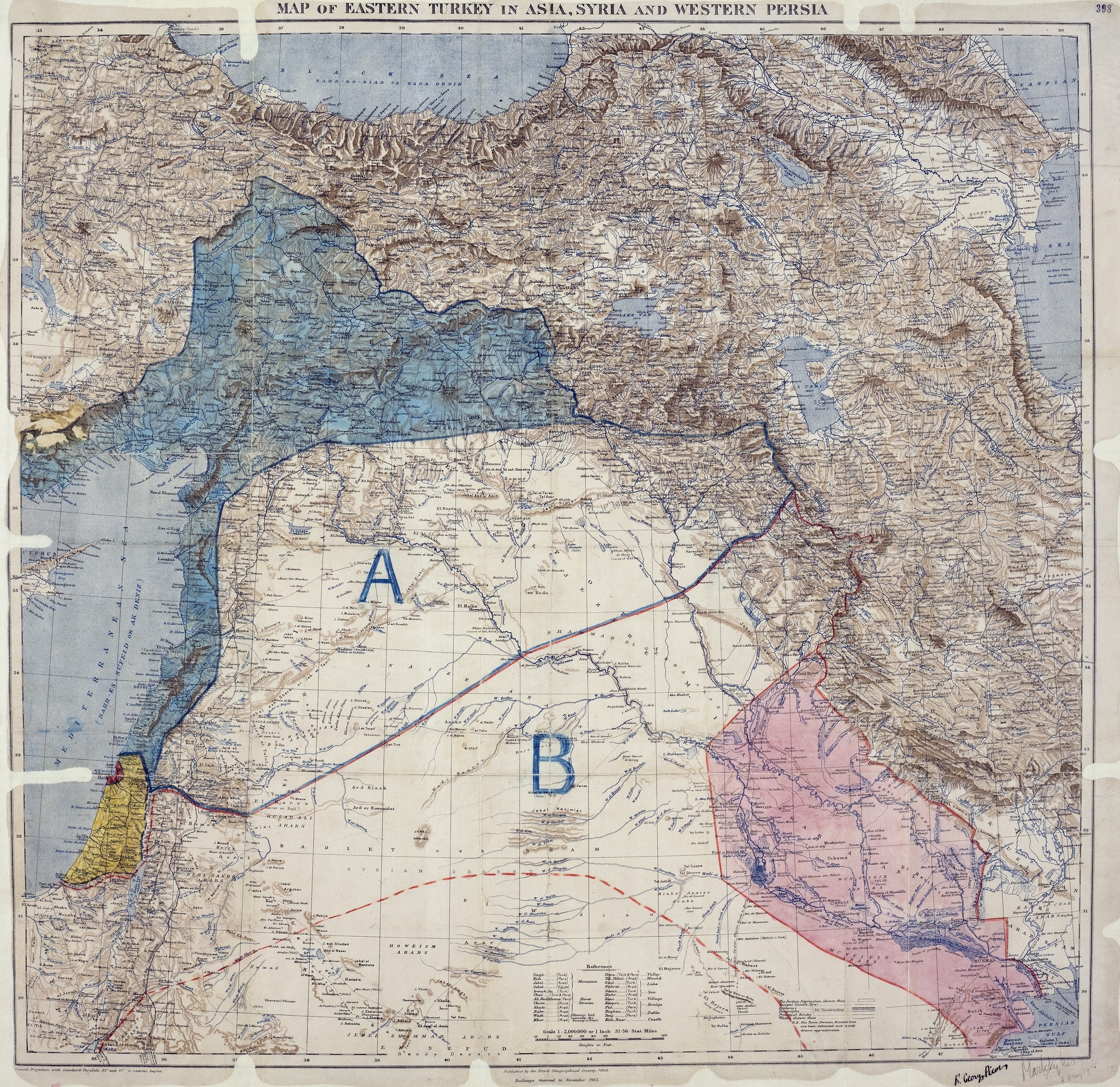
3. The Sykes-Picot Agreement
As the belligerents of World War I dug into their trenches in Europe, discussions among the Triple Entente turned to the question of how to parcel the territories of the Ottoman Empire. Each member of the alliance sought to secure their respective interests in the event of a breakup of the "sick man of Europe." An initial deal reached in March of 1915, called the Constantinople Agreement, proposed to cede Constantinople (Istanbul) and parts of northern Anatolia to the Russians, providing them with access to the Mediterranean Sea. France, with significant economic interests in Syria already, sought to bolster its partnerships and establish for itself a zone of control on the Levant, providing it with invaluable strategic ports. Whereas Britain sought to establish a secure trade corridor with its holdings in India via the Suez Canal and the Persian Gulf.
With the war winding down, and with Russia undergoing severe difficulties on the war-front, the British statesman Sir Mark Sykes together with his French counterpart François-Edouard Picot, went about their task and began negotiations on a secret deal. Apparently, when Picot probed Skyes about where he would divide the Middle East between the two powers, Sykes hastily pointed to two locations on his map and drew a straight line. When you look at the contemporary border between Syria and Iraq, what you see is, for the most part, the same lime drawn by Sykes. Everything south of the line would end up in British hands, while everything to the north would go to the French, with each retaining free passage and trade in the other’s zone of influence. Initial Russian involvement as part of the Triple Entente came to an end with the Bolshevik Revolution in 1917, and after the Bolsheviks came to power they published the secret agreement causing considerable embarrassment for both the British and the French.

Sykes-Picot Agreement, (8 May, 1916) Showing Eastern Turkey in Asia, Syria and Western Persia, and areas of control and influence agreed between the French (A) and the British (B).
Source: Wikimedia Commons, available here.
The Arabs, who had learned of the Sykes-Picot Agreement through the Russian publication, were outraged. This secret arrangement conflicted with promises already given by the British to the Sharif of Mecca as part of the Ḥusayn-McMahon Correspondence. Operating based on the understanding that the Arabs would eventually receive British-supported independence, Ḥusayn had brought the Arabs of the Hejaz into open revolt against the Turks in June 1916. When the promised independence for the Arabs did not materialize after World War I, and as Britain and France throughout the 1920s, 30s and 40s continued to exert immense influence over the Arab world, politics in North Africa and in the eastern Mediterranean began to shift from liberal constitutional governance systems (such as Egypt, Syria, and Iraq in the early decades of the 20th Century) to one's embracing an assertive nationalism whose main objective was expelling colonial powers and their systems of rule. The rise of pan-Arab nationalism saw an increased focus on expelling imperial powers with political declarations from those in the movement often taking the shape of a direct critique of the Sykes-Picot agreement. In this light, the Sykes-Picot agreement was a key factor behind the rise of the militarist political regimes in many Arab countries from the 1950s onward.
But aside from broken promises, the border itself was almost entirely a straight line running through the Syrian Desert. In effect, it split up significant ethnic populations of Kurdish and Druze peoples, leaving them as minority populations across several different states, and sowing the seeds for further unrest. While the desert might have seemed like some impassable, logical barrier to use as a delineation to the British or French, it could hardly be said to mean much the same to the roaming Arab tribes that have occupied that land for millennia. As they disregarded the ethnic communities on the ground in their policy calculations, the foremost colonial powers in the Middle East divided former Ottoman holdings in the pursuit of their own interests. The Treaty of Lausanne would then come to recognise Turkish interests, and in doing so sideline the Kurds once more.
My intention in outlining these three border settlements is not to lay the entire blame of century-long conflict upon those who established them. Instead, I think by highlighting the logic of their formulation, the actors which influenced it, and the applicability of those influences to the reality on the ground, we can better understand why some conflicts endure directly because of such settlements. The most pressing lesson from all three examples is that drawing lines on maps while disregarding the topography of the space in question, and more importantly the cultures which occupy a given area, is a recipe for future conflict. I am not saying that these regions would have been more stable, or these peoples better off, had the borders been drawn strictly according to ethnic considerations. Instead, I think we should look to be more aware of what contributes to the complexity of both inter-state and intrastate conflict and instability, and the way in which past settlements continue to cause grief well into the 21st century. In all three areas where such borders were drawn, stability and peace remain unlikely in the future.